KiwiWalks

Hamilton City Traverse

I’m in Cambridge at the moment, working at a summer job – oh, the delight. But I got today off and so went and did another section of Te Araroa – the Hamilton City Traverse. To be difficult, I did it all topsy-turvy.

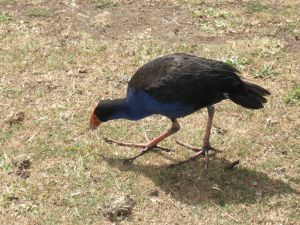
I started at the Taitua arboretum – a gorgeous wee place that I’d not seen or heard of before, and what a nice surprise it was. I’d definitely go there again. The place was full of birds, especially chickens. The arboretum is built around farm land, and there are two paddocks in the middle of it, so the arboretum and the farm are merged. Anyway, at several strategic points around the paths (and I spent an hour circling the place, because it was early and I had heaps of time and it was just too pretty to miss) there are chicken coops. The fat friendly chooks obviously expect human=food, and so I ended up trailing chickens, looking like a demented  Pied Piper. Alas, the chooks were disappointed. There were also lots of pukeko: a native bird about the size of a chook, with truly enormous feet.

OLYMPUS DIGITAL CAMERA

After leaving the arboretum I made my way to Till’s lookout, and then into Hamilton city centre. Here I stopped to have lunch and go to the movies. I saw The Lovely Bones, and lovely it was too. Then I took the bus out to Pukete – the other end of the HCT, and walked back to meet myself in the middle (city centre) of the walk again.

The track from Pukete was all along the Waikato river; it was very well done, although my feet were getting tired of pounding pavement by the time I’d finished. Still, I took the time to end the day on a short detour, to see the Riff Raff statue. Richard O’Brien, creator of and actor in The Rocky Horror Picture Show, spent (or misspent) his youth watching B horror films in Hamilton, and I love that they’ve commemorated this with a statue of an alien transvestite (along with instructions for doing the Time Warp).

OLYMPUS DIGITAL CAMERA

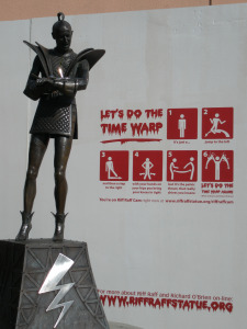
It’s just a jump to the left…

KiwiWalks

Tongariro Alpine Crossing

I got a nice surprise today! I was trawling through the Te Araroa website looking for my next walk, when I discovered that, all unbeknownst to me, the Tongariro Crossing was included. I actually did this walk several years ago, on New Year’s Day, and it still ranks for me as the best walk I’ve done – and that includes the Milford Track, which is popularly supposed to be the most spectacular in New Zealand. Anyway, I’m not about to repeat sections I’ve already done – it’s the same with the Milford Track (I want to do all the Great Walks, but have already done Milford and therefore don’t feel obliged to do it again). So that means I can tick off the Crossing.

It was a lovely sunny day when I did it, and I could see Mount Taranaki clearly from the top of the Devil’s Staircase. Walking through the South, Red, and Central Craters was amazing; Mount Doom (aka Ngauruhoe) satisfied my inner fangirl; and the tussock landscape around Ketetahi is just beautiful. (I spent several years on my OE and missed tussocks more than anything else, I think – I love the way they look, and fields of them waving in the wind somehow feels like home.) It’s a shame I’ve lost the photos, but I’ll be going back to Tongariro National Park sooner or later to do the Northern Circuit (another Great Walk) and that covers the same ground, really, as the Crossing, so I’ll take more then.

So that’s another tiny bit of Te Araroa shaved off. I’m feeling even more satisfied with the walk in retrospect, now.

KiwiWalks

Coast to Coast

Have left Dunedin for the warmer north, and am visiting my sister in Auckland for a couple of days. While I’m here I thought I’d do a bit more of Te Araroa – the Coast to Coast walkway. This goes from the ferry terminal in the heart of the CBD to Manukau Harbour; about 16 km in all. A relatively easy day.

OLYMPUS DIGITAL CAMERA

Heading out of the immediate shopping frenzy of Queen Street and the surrounding environs (including the spectacular Sky Tower, the tallest man-made building in New Zealand) I made my way up to the Auckland Domain. This is a multipurpose green space in the centre of the city, and lots of people were out enjoying it. The Auckland Museum is in the middle of the Domain, so I abandoned the walkway for a couple of hours to troll through it. They had dinosaurs! I was so excited. I could stare at dinosaur skeletons for hours.

After lunch at the Museum cafe, I headed across to Mount Eden, and hauled myself up to the crater. I’ve been there  a couple of times before, and always enjoy going. Mostly because, I admit, it caught my imagination as a young child, when I was reading Maurice Gee’s Under the Mountain, in which a red-headed twin throws a magic stone into the crater, thus bringing about the downfall of evil, quacking aliens called Wilberforces, who want to turn the entire Earth to mud. It’s better than I’m making it sound, truly. I loved that book.

An hour or so later I was doing the same thing at One Tree Hill (minus the sci-fi reminiscences of my childhood). One Tree Hill is a complete misnomer, I’m afraid. Firstly, because it’s lower slopes are covered with a lot more than a single tree. And secondly, because although it once had a single tree at the top, as far as I recall someone threw a tantrum and cut it down, so now there’s no tree at all. Grrrr. I’m a botanist at heart, and chopping down trees for the hell of it really pisses me off.

onetree

From OTH I trotted towards the end point, Onehunga Bay Reserve, a small park on the edge of Manukau Harbour and the end of the trail. A really good day, on a very well-done trail. I especially liked how as much of the walk as possible was through green spaces – it wasn’t just trekking through roads and obviously urban environments, which would have been easy to do. Got quite sunburnt, though. Must make sure not to forget my sunscreen again!

KiwiWalks

Turnbull Hut

Turnbull is a basic bivvy hut, the lowest grade of Department of Conservation huts. Four walls and a roof, plus fireplace and bunks and not much else. Nonetheless, it was chock-full of character, and had obviously been used and enjoyed for decades.

OLYMPUS DIGITAL CAMERA

I spent an extra day there, partly because after two very long days I was tired, and partly because I’d wrenched one of my ankles in all that bloody mud and could barely limp across the hut floor. Seriously, I couldn’t understand it. By some miracle it hadn’t rained for days, and yet mud was still stubbornly and deeply present, ever ready and waiting to try and take a boot. It nearly did, too. It must need an entire summer’s drought to dry up the last of it.

The area around the hut was the most beautiful I’d seen in the Longwoods – trees straight out of Fangorn Forest. And there was this beautiful little old dam which on its own was worth the entire walk: one of the prettiest little lakes I think I’ve ever seen.

OLYMPUS DIGITAL CAMERA

However, these two unscheduled extra days had left me short on food, so after another night at Turnbull I had to stumble back down to the end of Cascade Road. Amusingly, 15 minutes or so after I had left the hut (and, it must be said, this was, unlike PWR, a very well marked track, with blazes nearly every 5 m ((I amused myself thinking about Orange Gordon and his amazing trained pack-sheep, Bertha)) I came across a sign I had seen and cursed the day before yesterday. 5 MINUTES TO HUT. Needless to say it was wrong,  broken, and resting in a pool of mud, but some other annoyed and teased-beyond-endurance tramper had vandalised the sign to give a more accurate impression. I’m betting it wasn’t a Southlander.

Truly unfortunately – I still can’t understand how it happened – at the bottom of Cascade I got turned around and starting heading for hours down this horrible gravel road. Too late I realised I was nearly back at Riverton, rather than going onwards to Otaitai, but after a minute of reaction I shall not repeat I had to laugh. Hitched a ride on an empty schoolbus back to the Globe in Riverton, and gorged myself stupid on pizza and beer, before deciding that I think I’d had enough exercise for now, thank-you, and headed back to Dunedin.

KiwiWalks

Port Water’s Race, still

Waking early after my impromptu stayover in the mine-studded forests of Longwood, I made plans to get the hell out. Hopelessly lost and off path, and map seeming worse than useless, I breakfasted on chocolate and made the decision to head east. East was out, at any rate. So, with the helpful warnings of the Colac Bay pub-goers in my mind (“don’t get off track, there are old mines 50 foot deep you can plunge to your screaming death into”) I set off – being very careful about where I put my feet.

In a stroke of luck that I still can’t understand (having very stupidly wandered lost for a good hour the night before) within the hour I had stumbled onto the PWR track again. Unfortunately, it was a bit I’d already travelled – which meant that I still had the path of confusion before me. You’d think it would be fairly easy to follow a bloody great ditch, even when the path petered out, wouldn’t you? But if the thing is clogged, or there’s been a slip, or the path is for some reason impassable and you have to force your way through the bush around it and somehow hope for the best, well, things happen.

Coming again to the mystery spot, I somehow stumbled on the correct path. You see, you get to this river. On one side is a path that has obviously – from the state of the path itself, which is quite evident – led many unsuspecting people off into darkness and terror, while the real route, marked with a small scrap of cloth, is on the other side of the river, heading up a steep and overgrown bank with no evidence of a path at all. Again, it was force and hope – a theme to be repeated through much of the afternoon.

Then, stumbling along, a miracle. Cascade Road (a deserted farm track) appeared through the trees. No signage, of course. (And what Southlanders have against decent signage I don’t know – did it get them to a mother-in-law’s birthday party on time? – but there is apparently an immoveable regional grudge against it.) 31 hours after I started that supposedly 8 hour track I stumbled free of it, with a determined resolve never to take any Te Araroa guidelines seriously in future. 8 hours, bullshit.

I stumbled up Cascade towards Martin’s Hut, only to find that the promised clear signage was non-existent. I eventually found the track to Turnbull Hut, but only because the sign had not been removed entirely. Rather, it had been broken off and thrust head first into a gorse bush of gargantuan proportion. 1/2 hour to the hut, it said, and again: bullshit. I arrived 2 hours later, muddy to the bone, just as it was getting too dark to see, and you know what?

Turnbull Hut was worth it to the core.