KiwiWalks

Longwoods Ranges

I had high hopes for today. I thought it would be an interesting experience. Well, it was an interesting experience alright.

First, I had to tramp the 4 km or so of roading to get to Round Hill road, the entrance to the Long Hilly Track – which is neither long nor very hilly. The LHT is a historic walk through the bush site of old goldfields much favoured by the Chinese immigrants of the time. What was once a thriving little community – including hotels and pubs – is now gone, but there are some traces of the mining operations left. It’s a 2 hour return track, and is extremely well done, with information panels dotted around the place to tell you about its history. A lovely little walk.

About 45 minutes up, I came to the Port Water’s Race turn-off. PWR is a marvel of engineering – roughly 25 miles long (back before sensible metric) this finely sloping ditch channelled water for sluicing. Its gradient is so minimally perfect that the water moved slowly and easily through the bush, with no rushing or rapids – and for it to be hacked out of the earth and stone at the time (even tunneling through rock in some places) was no mean feat for poverty-stricken miners of the 19th century. Remnants of their presence are scattered along the track – like this old broken bridge.

OLYMPUS DIGITAL CAMERA

A sign at the beginning of PWR assured me that the section to Cascade Road should take me 8 hours. I don’t know what roadrunner did this trail in 8 hours, but it must have been in better condition then! Mud, mud everywhere, broken trees and debris all over the path, and – it has to be said – a very lackadaisical attitude to marking said path or giving any signage at all meant that, close to 12 hours after I started walking PWR I had to camp out under the shelter of an enormous dead tree, completely lost.

At least it wasn’t raining and I had the sense to bring supplies, but still. Was not amused. Thank goodness no bears or other nasties in NZ! I might have been grumpy, but at least I could go to sleep secure in the knowledge that, like Granny Weatherwax, the most dangerous thing in those woods was me.

KiwiWalks

Colac Bay

Here I am in Colac Bay, which is only about 10 km of road walk (boo, BOO!) from Riverton (oh, alright, it wasn’t that bad). It’s a short leg, but it’s also the natural stopping place, so I don’t feel too lazy, even if I did have a nana nap after I got here. Longwoods Range tomorrow – bush walking! I’m looking forward to it.

This afternoon I went walking around the Bay, which is a really pretty and peaceful little place. Did some laundry – yes, very exciting. Went to the pub attached to the backpackers – and although I really want to stop spending so much money there wasn’t any other option. A word of advice for anyone tramping this part of Te Araroa – Colac Bay is lovely but you’ll need to get your food in Riverton and carry it on over. There is nowhere here to buy food – I mean nowhere. No dairy, no service station, no takeaways, nothing. At least the pub sells chocolate bars, so I nearly cleaned them out to get through a day or two of Longwoods tramping. Thank goodness I picked up some extra bread and cheese in Riverton…

KiwiWalks

Oreti Beach

After my much needed rest day in Invercargill, in which I hobbled round like a very lame hobbled thing, I strapped the pack on for the first time to tramp up to Riverton. The pack itself isn’t bad – comfy, and felt quite light. But after 10 hours of walking I was to feel quite differently…

First, another hated section of road walking. Boo. Boo! A couple of hours out past Invercargill airport and down to the famous Oreti beach, where Burt Monroe trained on The World’s Fastest Indian. It was a lovely beach, and I don’t say that just because it wasn’t tarmac. It really was – and better, people were using it as intended: walking, dog-walking, kite-surfing, swimming… It was also nice and easy to walk on, the sand well-compacted but not too hard.

OLYMPUS DIGITAL CAMERA

My problem was the creek. I knew that halfway down the beach there would be a creek that could be quite tricky under the wrong conditions. I’d read Jacob’s blog about Te Araroa, and he stumbled into Riverton at 10 pm, after having to wait for the tide to go out enough for him to cross, and even then it was up to his waist. Besides, the people I met on the beach gave me ominous warnings: “Watch out for the creek…”

The tide was out, but I didn’t want to take any chances, and so I motored along the beach singing Motown at the top of my lungs to give me a beat to walk to (hey, there was no-one around to suffer my voice but me). Later than I had hoped, I came to the creek, stripped from the waist down, and waded across – only to find that the water only came a couple of inches above my ankles.

It was not long after this, kind of exhausted already, that Oreti turned slightly evil. Even coming across a seal sunning itself on the sand could only cheer me up for a few minutes. I could see Riverton in the distance, seeming close enough that I could reach out and touch it. I tell you, it didn’t seem one step closer for the next three hours. I kept thinking to myself “Must be there soon!” but it was like I was walking on a treadmill rather than a beach.

OLYMPUS DIGITAL CAMERA

Calling up the Globe Backpackers in Riverton gave me some breathing space – they had a music night on and so were going to be open very late. Which was good, as I finally staggered in about 8 pm, feeling as if I had knives in my feet. It took me all of three minutes to drop the bag and head for the bar – I’d been dreaming about beer for hours.

And can I just say, the Globe is a fantastic place to stay. More like an old-fashioned family pub than a backpackers, it was friendly and cheap and delightful in every respect. I immediately booked myself in for two nights, because damned if I was walking another step the next day. (Although, surprisingly, the next day my feet were fine – certainly not like they’d been in Invercargill, where I was practically hobbled. But being lazy I took the rest day anyway. Hey – the idea of this blog is to get fit, not get fit in one quick horrible swoop).

KiwiWalks

Starting at Bluff

Here I am, in Invercargill, at the Tuatara Backpacker’s Lodge, and my feet have more blisters than bubble-wrap. After one day of walking only… I thought I’d give part of Te Araroa a go, and walk from the start/end at Bluff to the next stop at Invercargill. I left my pack at the Tuatara, and took a day pack with me on a shuttle bus down to Bluff. I reasoned that not taking my full pack would also be easing myself into it. (Cue hollow laugh…)

I knew it wouldn’t be a very nice trip. The TA map of Southland has a Schrodinger’s cat version of a trail for the bulk of this section. Little dots where it will be in theory, but these dots aren’t connected by the colour for a completed track or the colour for an unformed track. I knew it wasn’t formed, because the few other people I know who have done this section have done it on the marked detour – State Highway One. They all hated it. And why wouldn’t they? 20+ kms of hard, hard road, with no amenities of any kind and nothing interesting to see. On the bright side, I figure that I got the worst over first.

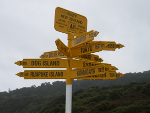
It didn’t start off that bad, because the first little bit didn’t start on the road. After being set down at Stirling Point, the official beginning/end of TA, and getting a photo of the famous signpost, I spent 45 minutes walking Foveaux Walkway, a pleasant little trail suitable for all ages. It rained, but I had my waterproofs on so it wasn’t too bad.

OLYMPUS DIGITAL CAMERA

Then I hit it. The Ocean Beach pathway, leading to SH1. A barely there trail, with yellow topped posts scattered at long-distant intervals to let you know you’re going the right way. At times I could barely see one post from another, but I managed. The trail (a term I use loosely) was rocky, muddy, wet, and steep. And by this time it was hailing. But I was dressed appropriately, and wasn’t cold. The hail bounced harmlessly off. I theorised that the reason for this trail was simple. If one was very lucky, and was stumbling along in rain and hail and wind (let’s not forget the gale force wind), muddy and having to clutch at gorse to stay upright, then the upcoming nightmare of SH1 becomes something to look forward to. I’d been dreading that highway, but by this time I was positively delighted with the idea of it.

Before that, however, the Ocean Beach portion passed into farmland – or what was by then practically a bog. I spent an hour picking my way through it, and only pretending to be Gollum in the Dead Marshes got me through it. Yes, I even did the voice. “Orcs don’t see it, orcs don’t know it!” I hissed at the top of my lungs. “Nasty Orcses…!”

As no doubt planned by the cunning minds at TA, once I stumbled onto sH1 I was positively drooling with gratitude to see it. That lasted for about 10 kms or so. It was every bit as dreadful as I feared – it just took me longer to realise it, not being in the Dead Marshes and all, and anyway the rain had stopped. The fact that the wind – still gale force – had only two directions (straight on, trying to blow me back to Bluff, or from the west, into the path of an oncoming lorry) was an aiding factor in my realisation. And the road might have gone ever on and on for Bilbo, but he was going to Rivendell and, well, with the best will in the world Invercargill just doesn’t compare, so I stopped singing that after a very short while, and moved on to Tiki Taane, in an effort to get my mind off things.

On I stumbled, hour after endless hour, refusing lifts from concerned citizens with a cheerily demented “I’m doing the trail!”. Then several kms out of Invercargill, and having just passed a petting zoo, disaster struck. It begain hailing again – really hailing, much harder than on the Ocean Beach cliffside. I was in waterproofs and more layers than a Russian Matrushka doll, but it still hurt like hell. Some of them even managed to draw blood from the few exposed pieces of skin I had left. Then I took another step and the enormous blister I’d felt forming under my big toe burst.

At this point arrived my knight in shining armour. A good Southern Man, in a beat-up car liberally sprinkled with empty Speights cans, Alan pulled up and asked if I wanted a lift into town. It took approximately 0.007th of a millisecond before I decided that cheating was allowable under the circumstances and threw myself into his car. Alan, it turns out, was a little under the weather himself – he’d caught a cold a few days earlier cheering on Southland against Canterbury at the Ranfurly Shield match. I’d seen the parade in Invercargill when the Stags were (miracle of miracles!) victorious. So I like to think he knew how I felt. It was only after he dropped me back at the Tuatara that I got a look at myself. (The strange looks I was getting from others should have been a clue, but I was too exhausted to care). But once I brushed my hair into less of a fright and wiped the blood off my face, I decided: tomorrow would be a rest day.

And as for those other poor souls thinking of doing Te Araroa… all I can say is that until the Schrodinger’s Cat trail decides whether or not it exists, start or end your trip in Invercargill. 20+ kms on SH1 is in no way worth it, and there’s no guarantee that Alan will be there to save you.

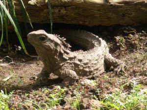
On the bright side, the stopover did give me time to see Henry, Invercargill Museum’s most famous tuatara.

henry